Be First to Download.

CYA Outdoors is coming to Android and iOS. Drop your email and we'll ping you the moment it goes live.

Android — Google Play

Coming Soon

Android Launch

Get notified the moment CYA Outdoors hits the Google Play Store.

✓ You're on the list. We'll email you at launch.

iOS — App Store

Coming Soon

iOS Launch

Get notified the moment CYA Outdoors hits the Apple App Store.

✓ You're on the list. We'll email you at launch.

Alberta & British Columbia · Free at launch

Crown YourAdventure.

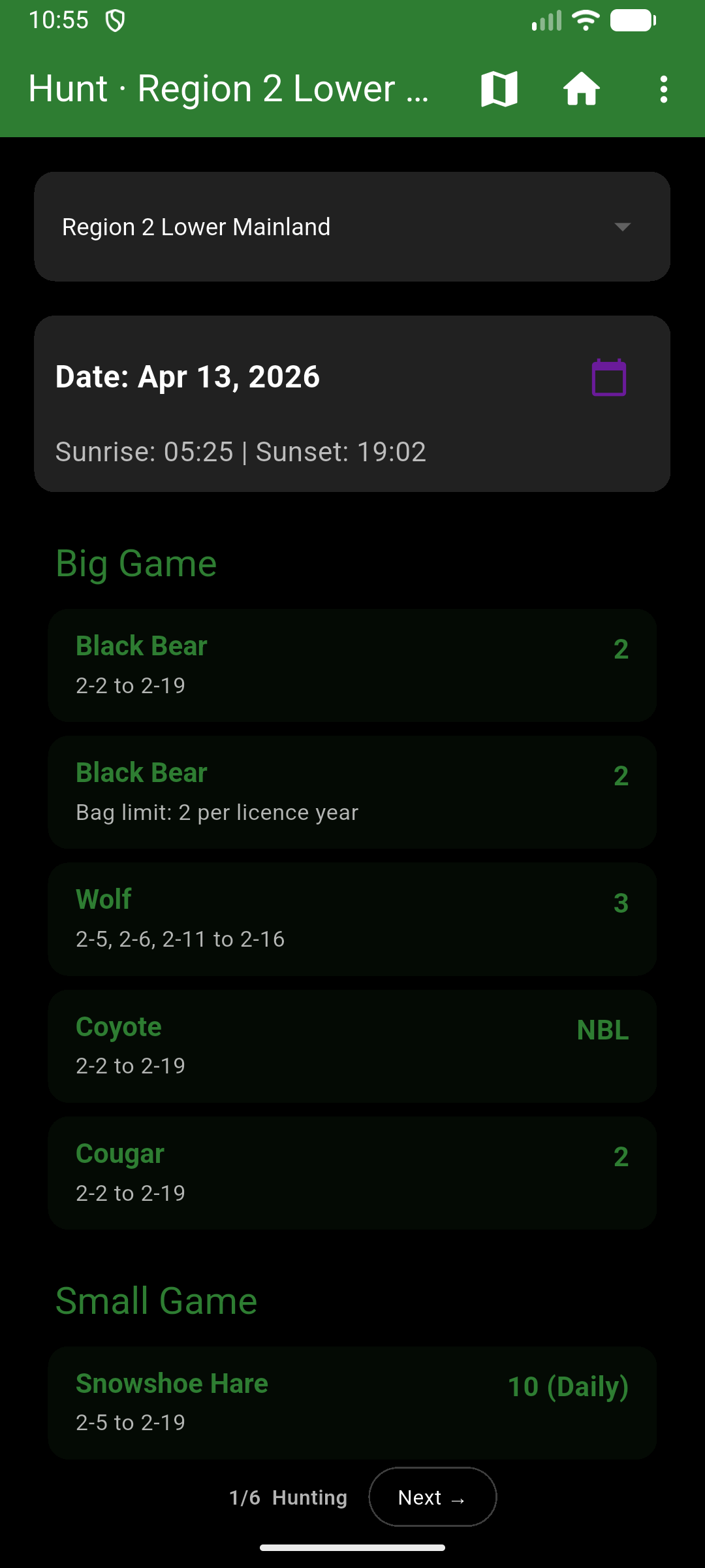
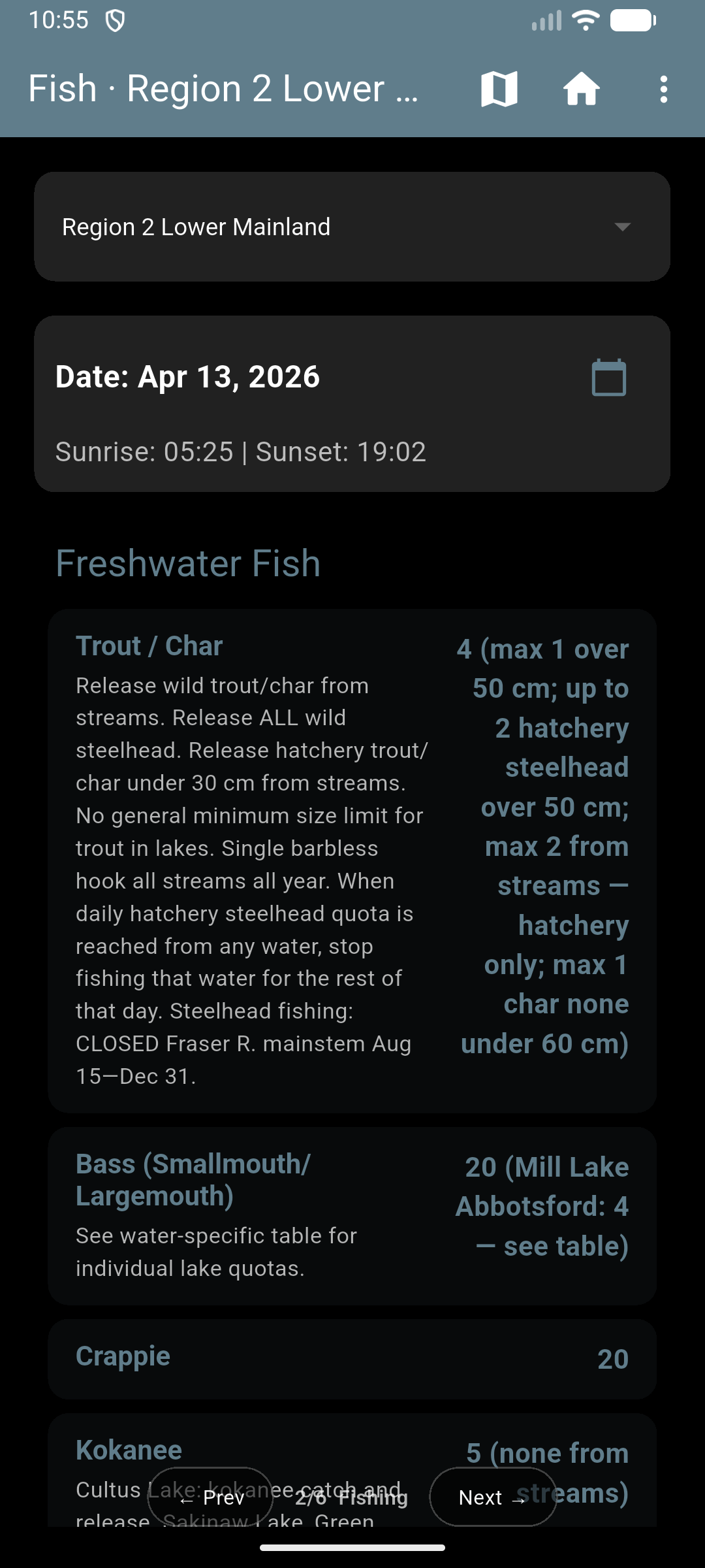
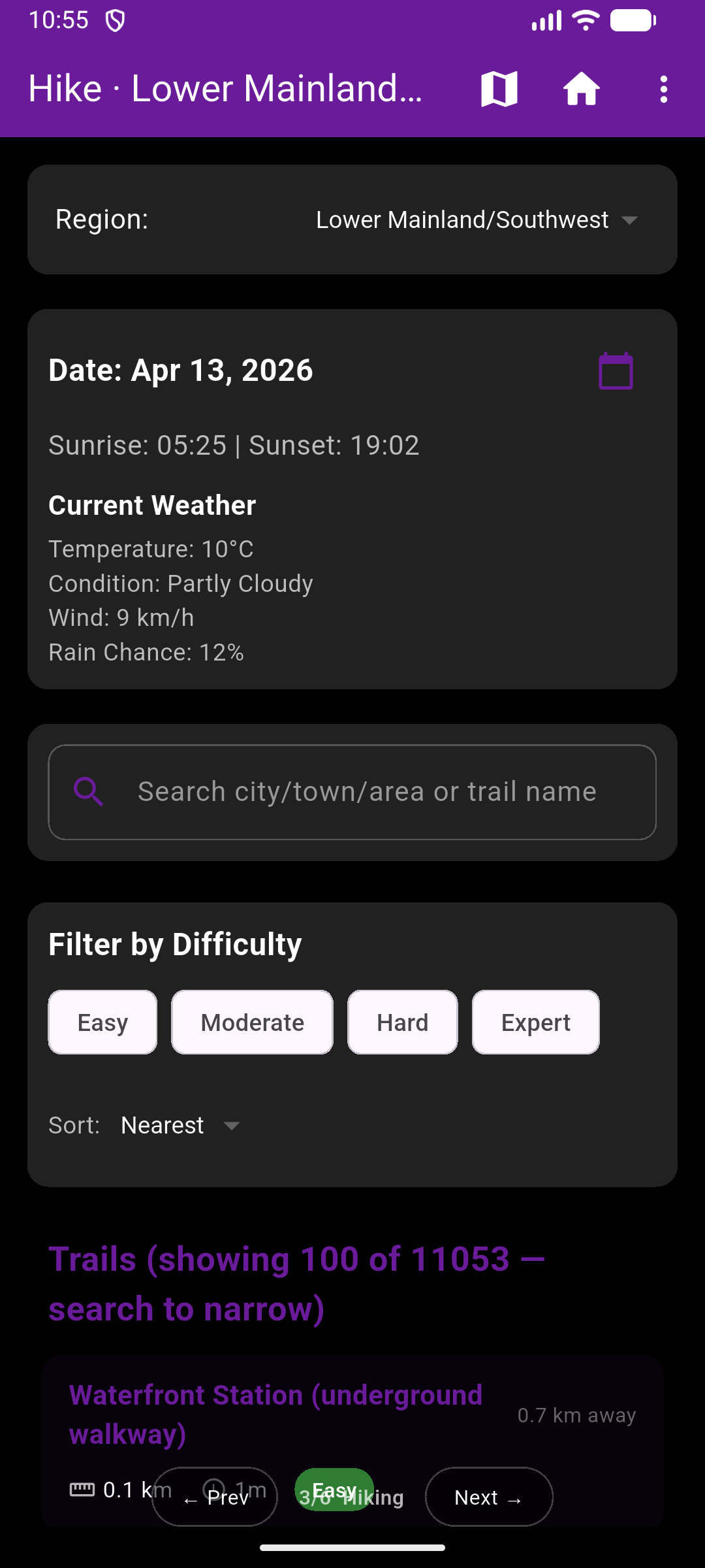
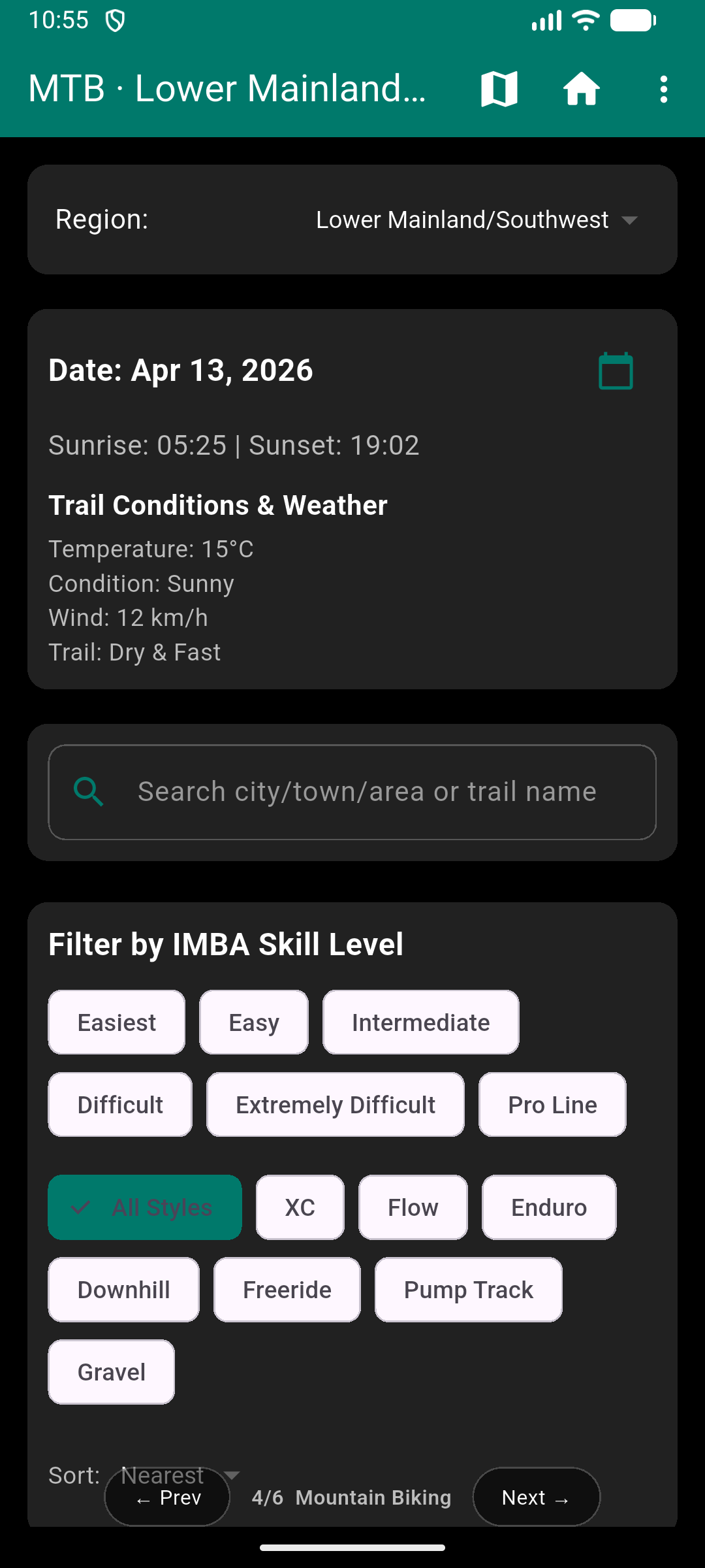
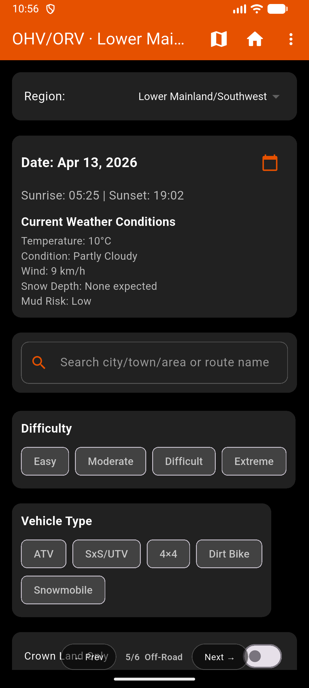
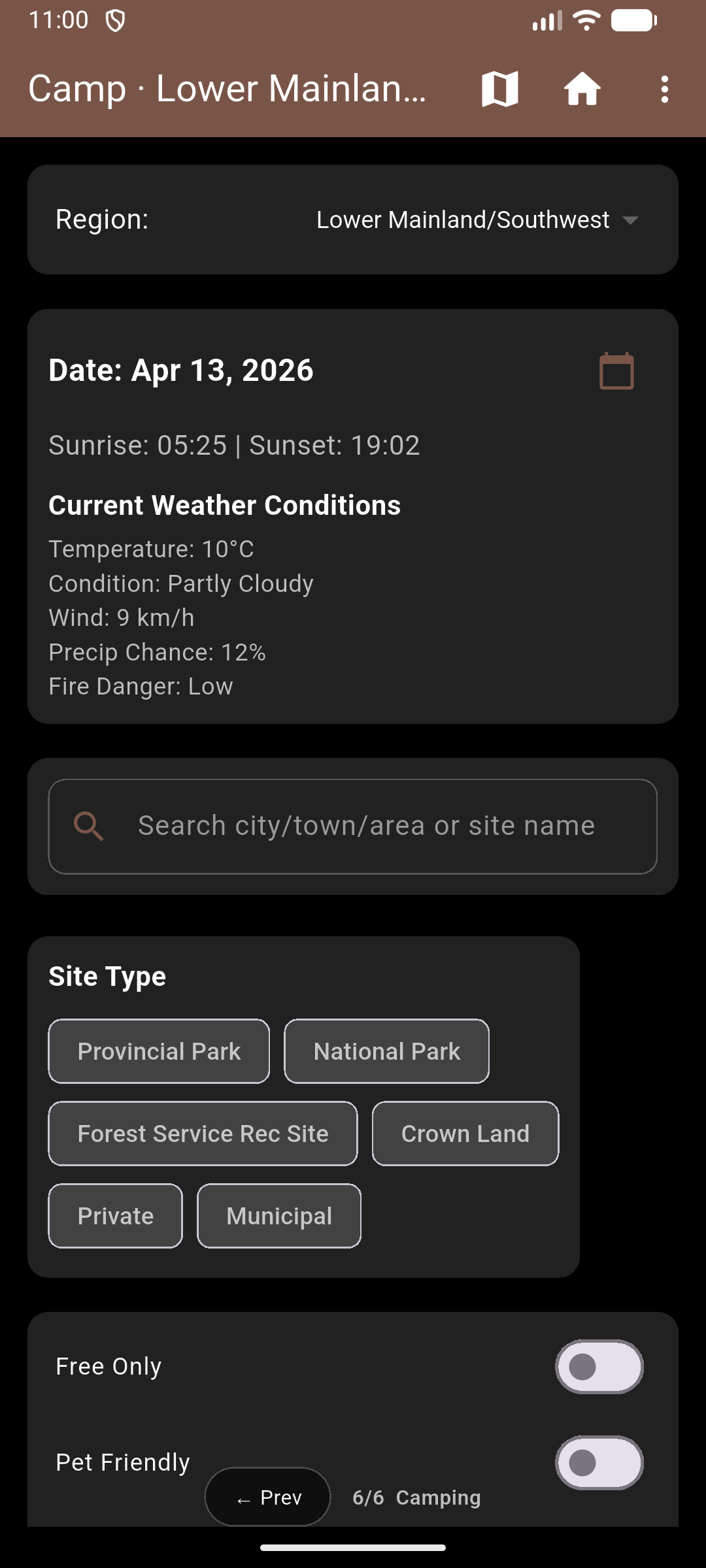
Hunt · Fish · Hike · Ride · Camp

WMU boundaries. Crown land. Fishing zones. Regulations. Trails — all on one offline-capable map. Built from the ground up for Western Canada's backcountry.

FREE
DOWNLOAD Alberta & BC
Hunting
Fishing
Hiking
Mountain Biking
Off-Roading
Camping
Alberta
British Columbia
Saskatchewan — Coming Q2 2026
Manitoba — Coming Q2 2026

Everything else makes
you pick one app.

01

Canadian-first. Always.

Built from the ground up for Canadian WMU systems, Crown land designations, and provincial regulations. Not a US app with Canada bolted on — every layer, season, and zone is native to how Alberta and BC actually work.

02

Six apps in one download.

Replaces iHunter, AllTrails, Trailforks, onX Offroad, and Hipcamp — with shared offline maps, shared GPS waypoints, and a shared track recorder. One account. One download. One map.

03

Offline. Full stop.

Download your province before you leave town. Hunt, fish, ride, and navigate with full maps in dead zones, on Forest Service roads, and deep in the bush — no cell service required, ever.

04

Cross-activity context.

A hiker sees they're walking through WMU 5-15 during elk season. An off-roader sees Crown land status mid-ride. A camper sees which fishing zone their site is in. No other app connects the backcountry this way.

Every activity.
One map.

Hunting

Full WMU boundary maps for Alberta and BC — all 9 BC regions and 6 AB regions, colour-coded and GPS-detectable. Know your zone from the moment you open the app.

  • BC regions 1–8 & AB regions 1–6: WMU boundaries, GPS-detected
  • Crown land, Range Tenure, Crown Tenures & Private Land overlays
  • LEH (Limited Entry Hunting) zone layer
  • First Nations Reserve and Mineral Claims layers
  • Season calendar by region — big game, small game, migratory birds
  • Hunting regulations PDF viewer bundled in-app — no internet needed
  • Species identification — big game, small game, birds
  • Scent cone visualizer with live wind direction data
  • Wind rose overlay for stand and blind placement
  • Sunrise, sunset & legal shoot-time calculator (GPS-based)
  • Licence wallet — photo, scan via OCR, expiry tracking
  • GPS track recording with full history
CYA Outdoors hunting screen

Fishing

Alberta and BC fishing zone boundaries on your offline map. Season dates, bag limits, and special restrictions — right where you're standing. The full provincial fishing synopsis, viewable in-app without data.

  • Alberta & BC fishing zone overlays, GPS-detected
  • Season dates, bag limits & gear restrictions per zone
  • Fishing regulations PDF viewer bundled — works offline
  • Fishing lake pins on map with per–water-body rules at a tap
  • Fish species identification — legal sizes, photos, and notes
  • Sunrise/sunset & daylight hours shown in-app
CYA Outdoors fishing screen

Hiking

Trail search with difficulty, elevation gain, distance, and estimated time — from the Bow Valley to Chilcotin — on the same map showing your hunting zones and Crown land status.

  • Difficulty ratings from Easy through Expert
  • Trail types: Loop, Out-and-Back, Point-to-Point
  • Elevation profile charts for every trail
  • Feature tags: pet-friendly, wheelchair accessible, permit required
  • GPX track export for external GPS devices
  • Turn-by-turn navigation launch from trailhead
  • Crown land and WMU status visible on the same map
CYA Outdoors hiking screen

Mountain Biking

IMBA skill level classifications for every trail. Seven riding styles. Network badges for Whistler, North Shore, Squamish, Kananaskis, and beyond.

  • IMBA skill levels: White · Green · Blue · Black · Double Black · Pro Line
  • Styles: XC, Flow, Enduro, Downhill, Freeride, Pump Track, Gravel
  • E-bike compatibility filter
  • Direction: one-way, bidirectional, or context-dependent
  • Distance, elevation gain, and surface type for every listing
  • Crown land overlay visible while you ride
CYA Outdoors mountain biking screen

Off-Roading

Vehicle type filters. Road and trail classifications. Crown land status on every map. WMU boundaries visible mid-ride — the only off-road app in Canada that shows hunting zone context while you're on the trail.

  • Vehicle filter: ATV · SxS/UTV · 4×4 · Dirt Bike · Snowmobile
  • Road types: FSR, ORV Trail, Quad Trail, Logging Road, and more
  • Difficulty from Easy to Extreme
  • Crown land designation and access status layered on map
  • WMU boundaries overlaid on every off-road route
  • Offline-first: all route data downloaded, no cell needed
CYA Outdoors off-roading screen

Camping

Provincial parks, national parks, Forest Service rec sites, Crown land, and private campgrounds — all on the same map as your trails, fishing zones, and off-road routes.

  • Site types: Provincial · National · FSR Rec Sites · Crown Land · Private
  • Facilities: toilets, showers, fire pits, electrical, boat launch, and more
  • Vehicle access: Any · 2WD · 4WD · RV-Friendly · Tent-Only
  • Filters: pet-friendly, free sites only, reservation-available
  • Booking links to ReserveBC and DiscoveryCamp
  • Nearby trails and fishing zones shown for every campsite
CYA Outdoors camping screen

Every layer that
matters out there.

Provincial Crown Land

Public land overlay showing Crown land status province-wide.

Range Tenure

Grazing licenses and range tenure boundaries on Crown land.

Crown Tenures & Leases

Active Crown tenure agreements and lease boundaries.

Private Land / Parcels

Private property boundaries; detailed parcel map at zoom.

LEH Zones

Limited Entry Hunting zone overlays for AB and BC.

First Nations Reserves

Indian reserves and Métis settlement boundaries.

Provincial Parks

Protected Areas Network and provincial park extents.

National Parks

Parks Canada federal park boundaries and buffer zones.

Mineral Claims

Active mineral claims and tenure areas.

Fishing Lakes

Fishing-specific lake pins and zone overlays.

Contour Lines

Topographic contour lines for terrain awareness.

Hillshade

Shaded relief layer for visualizing terrain elevation.

No single competitor
covers more than two rows.

Feature CYA Outdoors iHunter onX Hunt AllTrails Trailforks Hipcamp
WMU boundaries (AB + BC)✓ BothUS only
Hunting regulations in-app✓ Offline PDF
Scent cone visualizer
Fishing zones (AB + BC)✓ Both
Fishing regulations in-app✓ Offline PDF
Hiking trails
Mountain biking trails✓ IMBA-rated
Off-road / ORV routesSeparate app
Campsite listings
Crown land overlay✓ FullBasicPaid
Offline maps — no paywallPaid onlyPaid onlyPaid only
GPS track + waypointsPaid
Canadian-first dataUS-firstGlobalGlobalMixed
Annual costFree / $15.99 yr$30–50 / province$35–100 / yr$35.99 / yr$89.99 / yrFree

Cya Later — Backcountry Safety Companion

Go further.
Stay found.

Expected launch: Q4 2026 – Q1 2027

SOS
Hold 3s

CYA Later.

Alert your buddies. Stay safe out there.
Standalone emergency beacon companion.
Uses the same account as CYA Outdoors.

Google Play — Coming Soon App Store — Coming Soon
⚠ Always call 911 in a life-threatening emergency. Cya Later notifies your personal buddies only — it is not connected to emergency services.
  • 🚨
    Press-and-Hold SOS
    Hold 3 seconds to prevent accidents. Broadcasts GPS coordinates to all your buddies the moment cell service is available. Message types: Send Help, Lost, Hurt, Custom, or silent Test.
  • 👥
    Buddy System via Invite Code
    Add trusted contacts using a 6-character invite code. When SOS activates, every accepted buddy gets a push notification and can track your live GPS pings in real time.
  • 🔔
    DND Bypass for Incoming SOS
    When a buddy sends an SOS, Cya Later wakes your screen even in Do Not Disturb mode — because an emergency can't wait until you check your phone.
  • 🔋
    Battery Saver Mode
    Reduce GPS broadcast frequency to extend battery life during multi-day trips while keeping the SOS signal live.
  • 📋
    SOS History & Stats
    Full log of past SOS events — sent and received. Readiness score shows whether your setup is current and your buddies are still active.
  • 🧭
    Guided 5-Step Onboarding
    Welcome → Add Buddies → Enable DND Bypass → Run a Test SOS → Readiness Summary. Know your network is actually set up before you head in.

Replace $200/year
in outdoor subscriptions.

Pick the activities you care about. Download offline. Head out. That's it.

Free
$0
forever
  • TBD
Get Notified
Pro Monthly
$2.99
per month · CAD · cancel anytime
  • TBD
Get Pro Monthly

Earn points for
getting outside.

Expected launch: Q4 2026 – Q1 2027

CYA

CYA Rewards

A points-based rewards program built into the app. Log trips, share routes, and contribute to the community to earn points you can redeem in the store.

  • 📍
    Earn points on every trip
    Log GPS tracks, mark waypoints, and use the app in the field to accumulate CYA Rewards points.
  • 🗺
    Contribute to the community
    Share trails, routes, and campsite info with the CYA community (with your consent) to earn bonus points.
  • 🛒
    Redeem in the Rewards Store
    Use your points balance on items in the CYA Rewards store — from gear discounts to Pro subscriptions.
  • 📊
    Track your balance and history
    Full points history and store visible inside the app. Opt-in only — your data is never shared without consent.

Province expansions.
New features. No spam.

Saskatchewan and Manitoba are next — Q2 2026. Ontario follows Q3. Be the first to know when your province drops, and get early access to new features before they're live.

✓ You're on the list. See you out there.

We're listening.

✓ Message sent. We'll be in touch.

Download the app

Google Play — Coming Soon App Store — Coming Soon

Location

British Columbia, Canada
Serving Alberta & BC at launch.

Province Roadmap

Saskatchewan & Manitoba — Q2 2026
Ontario — Q3 2026